Maps と Places
コレクションでコンテンツを整理
必要に応じて、コンテンツの保存と分類を行います。

Google が提供する充実した地図で世界を探索しましょう。
カスタム マーカーで場所を特定したり、画像オーバーレイで地図データを拡張したり、1 つ以上の地図をフラグメントとして埋め込んだり、付近のスポットの詳細を表示したりすることができます。
Maps SDK
Maps SDK for Android は Google Play 開発者サービス プラットフォームの一部であり、地図やカスタマイズされたマッピング情報をアプリに組み込むことができます。スタートガイドの手順に沿って、プロジェクトに Google Play 開発者サービスをセットアップし、Maps SDK の主な機能を確認してください。
アプリに地図を追加する
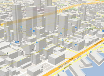
Maps SDK for Android では、XML スニペットを使用して地図をフラグメントとしてアクティビティに埋め込むことができます。この SDK は、3D 地図、インドア、衛星、地形、ハイブリッドの地図、効率的にキャッシュして描画できるベクターベースのタイル、アニメーションによる遷移など、魅力的な機能を提供します。詳しくは、地図オブジェクトを追加する方法をご覧ください。
地図をカスタマイズする
地図上にマーカーを追加して、ユーザーに特別なスポットを示すことができます。
アプリの外観に合わせて、地図マーカーの色やアイコンをカスタムで定義できます。アプリをさらに強化するには、ポリラインやポリゴンを描画してパスや地域を示すか、完全なイメージ オーバーレイを提供します。詳しくは、マーカーを描画する方法についてのガイドをご覧ください。
ユーザーのビューを制御する
地図の「カメラ」パースペクティブの回転、傾斜、ズーム、パンのプロパティを制御できる機能を使用して、世界に対する異なるビューをユーザーに提供します。詳しくは、ビューを変更する方法をご覧ください。
アプリにストリート ビューを追加する
アクティビティにストリートビューを追加して、ユーザーが 360 度のパノラマビューで世界を探索できるようにします。ストリートビュー カメラのズームと向き(傾斜と方角)をプログラムで制御し、指定された時間に対するカメラの動きにアニメーションを付けます。
Places API
ユーザーが現在地に基づいて店舗、レストラン、その他のスポットを見つけられるようにします。Places SDK for Android を使用して、ユーザーが必要なときに、連絡先情報や営業時間などの便利で関連性の高い情報を提供してください。
このページのコンテンツやコードサンプルは、コンテンツ ライセンスに記載のライセンスに従います。Java および OpenJDK は Oracle および関連会社の商標または登録商標です。
最終更新日 2025-07-27 UTC。
[null,null,["最終更新日 2025-07-27 UTC。"],[],[],null,["# Maps and places\n\nAllow your users to explore the world with rich maps provided by Google.\nIdentify locations with custom markers, augment the map data with image\noverlays, embed one or more maps as fragments, show details about nearby points\nof interest, and much more.\n\nMaps SDK\n--------\n\nThe [Maps SDK for Android](https://developers.google.com/maps/documentation/android-sdk/) is part of the Google Play services\nplatform and lets you include maps and customized mapping information in your\napp. Follow the [Get Started](https://developers.google.com/maps/documentation/android-sdk/start) guide to set up Google Play services\nin your project, then dive into the key features of the Maps SDK.\n\n#### Add a map to your app\n\nWith Maps SDK for Android, you can embed maps into an activity as a fragment\nusing an XML snippet. This SDK offers exciting features such as 3D maps;\nindoor, satellite, terrain, and hybrid maps; vector-based tiles for efficient\ncaching and drawing; animated transitions; and much more. Learn about how to\n[add a map object](https://developers.google.com/maps/documentation/android-sdk/map).\n\n#### Customize the map\n\nAdd markers onto the map to indicate special points of interest for your users.\nYou can define custom colors or icons for your map markers to match your app's\nlook and feel. To further enhance the app, draw polylines and polygons to\nindicate paths or regions, or provide complete image overlays. Learn more in the\nguide about how to [draw markers](https://developers.google.com/maps/documentation/android-sdk/marker).\n\n#### Control the user's view\n\nGive your users a different view of the world with the ability to control the\nrotation, tilt, zoom, and pan properties of the \"camera\" perspective of the map.\nLearn how to [change the view](https://developers.google.com/maps/documentation/android-sdk/views).\n\n#### Add Street View to your app\n\n[Add Street View](https://developers.google.com/maps/documentation/android-sdk/streetview) into an activity and let your users explore\nthe world through panoramic 360-degree views. Programmatically control the zoom\nand orientation (tilt and bearing) of the Street View camera, and animate the\ncamera movements over a given duration.\n\nPlaces API\n----------\n\nHelp your users find businesses, restaurants, and other points of interest based\non their current location. Use the [Places SDK for Android](https://developers.google.com/maps/documentation/places/android-sdk)\nto provide convenient, relevant information like contact information and\nbusiness hours when your users need it."]]